Log In or Create Account
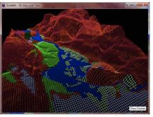
This mathematical model requires the use of MS Excel and ArcGIS. It uses digital elevation data and other information to simulate potential impacts of long-term sea level rise on wetlands and shorelines. SLAMM has been used in several geographies and applications across the nation since its development in the mid-1980s.
SLAMM accounts for dominant processes in wetland conversion and shoreline modifications during long-term sea level rise (SLR), and incorporates area protected by dikes, thereby providing more detail than static coastal topography alone. SLAMM also accounts for relative SLR calculated as the sum of historic global sea level trends, site-specific coastal elevation changes due to subsidence and other factors, and accelerated global SLR due to global warming.
See also Digital Coast's summary of this tool at http://www.csc.noaa.gov/digitalcoast/tools/slamm.