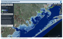
Online map-generation software from the NOAA Coastal Services Center that overlays social and economic data onto potential sea level rise data for a view of impacts on communities and tidal marshes from inundation and tidal flooding. Provides simulations of sea level rise at local landmarks, provides uncertainties, models potential marsh migration, provides information about projected tidal flooding frequencies. A slider bar is used to show how various levels of sea level rise will impact coastal communities.
The Sea Level Rise Viewer was developed to provide coastal managers and scientists with a preliminary look at sea level rise and coastal flooding impacts. The viewer is a screening-level tool that uses nationally consistent data sets and analyses. Data and maps provided can be used at several scales to help gauge trends and prioritize actions for different scenarios.
The tool covers the contiguous United States coastline as well as Hawaii, the Pacific territories, Puerto Rico and the U.S. Virgin Islands (not yet available in Louisiana and Alaska). In California, the maps use a 5-meter horizontal grid digital elevation model (DEM) and considers static sea level rise on top of mean higher high water (MHHW). The maps are created using a “modified” bathtub approach that includes a hydrologic connectivity assessment. This means that areas are only shown as inundated (in blue) if there is a feasible pathway for water to flow. Areas that are at or below the selected SLR elevation, but are disconnected, are shown in green. Visuals and the accompanying data and information cover sea level rise inundation, uncertainty, flood frequency, marsh impacts, and socioeconomics.