Log In or Create Account
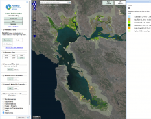
An online map viewer allowing the user to select sea-level rise and sedimentation scenarios and examine future tidal marsh habitat change, restoration potential, and conservation prioritization for the entire San Francisco Bay Estuary over the next 100 years. Maps produced using the Marsh98 model (ESA-PWA), high-resolution DEM, and spatially-explicit estimates of sediment supply, organic matter accumulation, and salinity changes. See also: Future San Francisco Bay Tidal Marshes, A Climate Smart Planning Tool
Limitations of this tool: · Modeling results are sensitive to the availability of suspended sediment and our estimates of the spatial distribution of sediment in the estuary do not incorporate fine scale heterogeneity in sediment availability. · The marsh accretion model is a one dimensional model and therefore does not account for the transport of sediment or other processes such as erosion. However, there is currently no other alternative modeling framework available for projecting these processes at the spatial and temporal scales applied in this report. · The restoration prioritization analyses only evaluated the potential habitat available for tidal marsh birds. Including other taxa would likely change the results. We recommend that future efforts should include the habitat needs of other taxa such as shorebirds. · The details of individual projects were not including in the modeling. For example, we did not change our base elevation layer to incorporate plans to raise initial elevations in subsided locations. Project specific plans could be incorporated in future analyses if the information is available and is spatially explicit.