Log In or Create Account
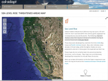
Map tool displays areas that may be in threat of inundation during an extreme flood event (100 year flood) for current and three projected sea levels. Uses a simple "bathtub" model; maps are available for the entire coastline.