
Article
Modeling Sea-Level Rise in San Francisco Bay Estuary
This research investigated site-specific projected sea level rise and storm impacts at a level of detail meaningful for protecting salt-marsh species-- detail on the order of the length of a wading-bird's legs.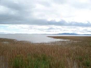 |
The project conducted intensive on-the-ground field data collection and innovative predictive modeling that incorporates local tidal conditions, marsh accretion rates, and habitat response to project possible future outcomes for critical marsh habitat at 12 sites surrounding San Francisco Bay estuary for sea-level rise. From these results resource managers can learn about the timing and locations of projected habitat change from sea-level rise and how this may impact the habitats for many tidal marsh species, including the federally endangered California clapper rail and salt marsh harvest mouse. At left, one of the project study sites by Karen Thorne. |
|
The Project's Website at the USGS Western Ecological Research Center offers access to a wealth of information for each of the 12 marshes: a detailed, graphics-rich description of the marsh's current and projected elevations, tidal inundation patterns, and vegetation communities; a time-lapse animation of the projected changes in elevation and habitat type; and all the spatial data and maps packaged for download. This research has been supported by multiple agencies, including the USGS National Climate Change and Wildlife Science Center, the CA LCC, and the U.S. Fish & Wildlife Service Inventory & Monitoring Program. Scientists are working closely with resource managers from the USFWS, CA Department of Fish & Wildlife, NOAA NERR, and local agencies to inform management decisions in light of projected sea-level rise. The work is now being expanded along the Pacific coast with partners that include the North Pacific LCC, California LCC, NW and SW USGS Climate Science Centers, and three joint ventures. |
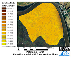 Above: 2 cm resolution map of elevation at Petaluma Marsh. Click the map for an animation of projected sea level rise at this location. |
| Get the Report Executive Summary and Full Report |
Explore the Study Sites Access the detailed data, animations, maps, and summary reports for each of the 12 project study sites |
Find the Project in the Climate Commons Project catalog record with related resources |
Coming Soon: Watch a Video Lead Scientist John Takekawa talks about the significance of the results for resource managers |
| Related Resources | |||
| Article | Sea Level Rise | ||
Last Updated:
1/2014